![]()
![]()
![]()
Urbanaut® Puget Sound Regional Monorail Master Plan (PSRMM)
The PSRMM Plan, as outlined below, applies the Urbanaut® technology, a new, unique, high tech monorail with numerous practical, technical, and environment advantages that cost less to install and operate. Urbanaut® has far more flexibility than any other monorail and it is not dependent on a beamway. Future additions and deletions can be made much easier with the Urbanaut®, with several options of lightweight guideway design and components.
PUGET SOUND REGIONAL URBANAUT®
MONORAIL MASTER PLAN
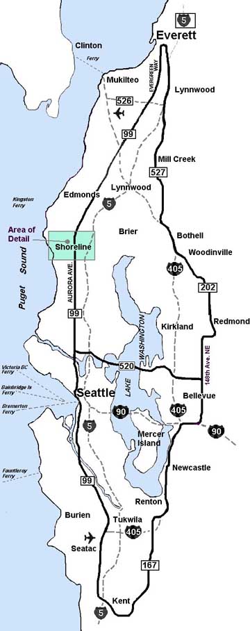
Illustration 1
|
|
The Puget Sound Regional Monorail Master Plan proposed for the Central Puget Sound, Washington, USA (Illustration #1) involves high capacity dual guideways along the following corridors:
Basically the overall perspective view of the PSRMM plan will be a configuration 8 layout with dual high speed switching connecting east and west ends of the 520 Central Connector across Lake Washington. A regional configuration 8 plan, as shown, gives most flexibility and efficiency in a high capacity monorail distribution plan because it provides the passenger several route options, namely:
With the trains stopping at every station at 2 miles apart, the maximum speed will be 80 mph (128 km/hr). For a traveling schedule where the trains stop every second station, or 4 miles apart the maximum potential speed is 115 mph (185 km/hr). This is close to the maximum allowable speed limit on a highway's right-of-way due to existing curvatures. The system will have large, 2-level high capacity intersection stations incorporating organized passenger feeding and supply systems, including facilities for loading and unloading of buses and vans, park and ride, car pools, and private carriers. |
SHORELINE, WASHINGTON URBANAUT® CIRCULATOR
HIGH CAPACITY MONORAIL TRUNKLINE
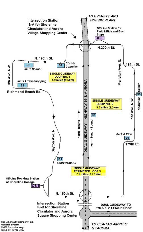
Detail of Master Plan
Illustration 2
|
|
In addition special smaller, independent single guideway Urbanaut® monorail circulators, extending into high density communities, will interact continuously with passenger transfer to and from the trunk line. The circulators using smaller vehicles will have dual functions: 1. To distribute passengers within the community; 2. To feed (unload and load) the trunk line by transfer or switching of vehicles directly onto the trunk line. The Urbanaut® is the only monorail system where smaller vehicles operating on a smaller guide way can be switched onto a larger high capacity guide way. An example of such a community circulation system is the single guide way layout recommended for the City of Shoreline (Illustration #2, "Circulator for City of Shoreline – Detail of Master Plan"). The Shoreline Circulator, using smaller vehicles, will serve schools, community colleges, public centers and shopping plazas, in addition to residential and multiple housing areas. |
![]()
![]()
![]()